Arunachal Pradesh: Satellite images show China build-up along Line of Actual Control
Don't Miss
We are keeping a close watch on brazen aggression and deployment shown by Chinese army over the past one year in the Tawang sector, says defence ministry official
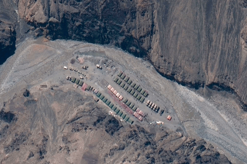
A close analysis of recent satellite imagery suggests a massive troop deployment by the Chinese in several depth areas, says a security official.: File picture
Imran Ahmed Siddiqui, TT, New Delhi, 31.10.23 : Satellite images suggest a massive deployment of the Chinese army along the Line of Actual Control facing Yangtze in the Tawang sector of Arunachal Pradesh, which witnessed Chinese incursions last December, sources in the security establishment told The Telegraph on Monday.
The development bolsters the suspicion, expressed by military veterans, that China intends to change the status quo in Arunachal the way it has done in eastern Ladakh, where it has occupied close to 2,000sq km of India-claimed territory since May 2020.
"A close analysis of recent satellite imagery suggests a massive troop deployment by the Chinese in several depth areas, especially Yangtze in the Tawang sector along the LAC," a security official attached to the Union home ministry said.
"Besides, they have undertaken major infrastructure development projects, including road-building, in the sector."
This is worrying, the official said, given that the sector witnesses frequent Chinese transgressions. "It's a major worry for us although the Indian army too has made enough deployment," he said.
Defence ministry officials refused comment on the latest satellite imagery. They, however, said they were keeping "a close watch" on the Chinese who are said to have set up additional military camps across the frontier from the Tawang sector.
"We are keeping a close watch on the brazen aggression and deployment shown by the Chinese army over the past one year in the Tawang sector," a defence ministry official said.
Defence minister Rajnath Singh had last week visited the Tawang sector in Arunachal, which China considers its own territory. Accompanied by army chief Manoj Pande, Rajnath had interacted with troops and reviewed India's military preparedness along the LAC.
The army has significantly bolstered the deployment of troops and weaponry along the LAC in Sikkim and Arunachal.
Twelve of Arunachal's 25 districts share a 1,126km border with China.
In December, a clash between the two countries' troops at 17,000ft in Yangtze, 35km northeast of Tawang in western Arunachal, had left 15 to 20 Indian soldiers injured.
The clash occurred after more than 500 Chinese soldiers allegedly crossed the LAC and began vandalising Indian military posts.
The Chinese troops tried to "transgress" the LAC and "unilaterally change the status quo" in Yangtze but their attempt was foiled by the Indian army, Rajnath had told Parliament.
In August this year, Beijing released the 2023 edition of its "standard map" showing Arunachal, the disputed South China Sea, and the Aksai Chin region occupied by it since the 1962 war as Chinese territory.
India says it "lodged a strong protest through diplomatic channels".


0 Response to "Arunachal Pradesh: Satellite images show China build-up along Line of Actual Control"
Post a Comment
Disclaimer Note:
The views expressed in the articles published here are solely those of the author and do not necessarily reflect the official policy, position, or perspective of Kalimpong News or KalimNews. Kalimpong News and KalimNews disclaim all liability for the published or posted articles, news, and information and assume no responsibility for the accuracy or validity of the content.
Kalimpong News is a non-profit online news platform managed by KalimNews and operated under the Kalimpong Press Club.
Comment Policy:
We encourage respectful and constructive discussions. Please ensure decency while commenting and register with your email ID to participate.
Note: only a member of this blog may post a comment.