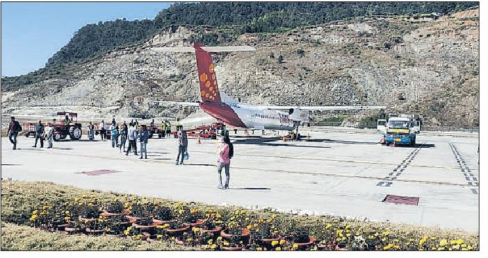
Plan to stop Pakyong flight
 SANJAY MANDAL, TT, 21 May 2019, Calcutta: The city's air connectivity with Sikkim will be snapped from June with SpiceJet deciding to withdraw its Calcutta-Pakyong flight, citing too many cancellations because of poor visibility.
SpiceJet, the lone airline licensed to fly to Pakyong under the Union government's regional connectivity scheme, had told the Airports Authority of India that unless navigational equipment is installed, it will not be possible to fly there. But AAI sources said because of a land problem, it was not possible to expand the runway and install instrument landing system.
"The flights were getting cancelled for most of the days because of poor visibility conditions. So, we have decided to withdraw the flights from June 1 and will only operate again if the navigational equipment are installed," Debjit Ghosh, regional sales manager, east, of SpiceJet said on Monday. "The passenger demand was also reducing because of the frequent cancellations," he said.
Pakyong airport was inaugurated by Prime Minister Narendra Modi in September last year. The air connectivity had created euphoria among tourists from Calcutta because it meant avoiding a five-and half hour journey through bad roads from Bagdogra. SpiceJet officials said in a month the flights would remain cancel for 20 days on an average. The airline operates a 78-seater Bombardier Q-400 series aircraft in the route. They said initially, the demand was very high and more than 85 per cent seats would be filled up.
"But, with so many cancellations, passengers were not sure whether the flight would operate and the demand has come down to around 50 per cent," said an official of the airline.
Passengers returning to Calcutta would get stranded and would have to arrange for car drops to Bagdogra, the nearest airport in India from Sikkim.
The minimum visibility required to land on the Pakyong runway is 5km (5,000m). At Calcutta airport, which now has a Category III-B instrument landing system, the lowest visibility at which an aircraft can land is 50m.
In the absence of navigation aids, pilots have to follow visual flight rules (VFR) for landing which means, a pilot must see where the aircraft is landing and that is possible only when the weather is clear.
But at 4,600ft, Pakyong usually has foggy weather conditions.
An AAI official said if the land issue was not resolved then the problem would remain.
Pakyong has a 2-km long runway and on about 800-m stretch, the width is 80 metres.
"To have instrument landing system, we need to make the runway width at least 150 m and also increase the length of the runway. We also need space to install radar. But the local villagers are not agreeing to give land," said an AAI official. He said several letters have been written to the state government, with which a MoU was signed for operation of the airport.
"But the land is yet to be acquired," he said.
He said if ILS was installed, the minimum required visibility would come down to 1200 metres. "But there seems to be no immediate solution," he said.


0 Response to " Plan to stop Pakyong flight"
Post a Comment
Disclaimer Note:
The views expressed in the articles published here are solely those of the author and do not necessarily reflect the official policy, position, or perspective of Kalimpong News or KalimNews. Kalimpong News and KalimNews disclaim all liability for the published or posted articles, news, and information and assume no responsibility for the accuracy or validity of the content.
Kalimpong News is a non-profit online news platform managed by KalimNews and operated under the Kalimpong Press Club.
Comment Policy:
We encourage respectful and constructive discussions. Please ensure decency while commenting and register with your email ID to participate.
Note: only a member of this blog may post a comment.